How to Find Property Lines for a Fence

Your property lines define the boundaries of your property and help determine where it begins and
ends. Property lines determine the exact shape and size of your lot or land and help determine
how close or far you are from your neighbor’s property.
Understanding your property’s boundaries is essential if you plan to erect a fence for privacy
or add an addition to your home.
Knowing where your property lines are also helps determine whose responsibility it is to remove
a tree, where you can legally plant a hedge as a border, or whose job it is to maintain it.
Therefore, before you begin a project that may approach the edges of your property, take the
time to locate your property lines first. Doing so can help ensure you don’t run into problems
later.
Step 1: Existing Documents – Your Deed
Locate a copy of your home’s deed; your deed has a lot of information about your property,
including where the boundary lines are and what types of access you may have to your property.
For example, if you need to go through your neighbor’s property to reach your own, this will be
detailed in your deed.
Locate the area on your deed entitled “legal description.” This section will describe where your
property lines are, most likely using the “metes and bounds” surveying system.[1]
The metes and bounds system describes your property lines using a bearing and a distance. For
example, it might give a starting point (e.g. road fork, boulder, tree), then direction (e.g.
N26W), then a distance (e.g. 327 feet) to an iron pin, followed by another direction and
distance.
Use these markers and directions to walk your property; they will give you an accurate sense of where the property lines lay. To navigate them accurately, use a compass and tape measure as you follow the written directions.
Step 2: Existing Documents – Your Plat
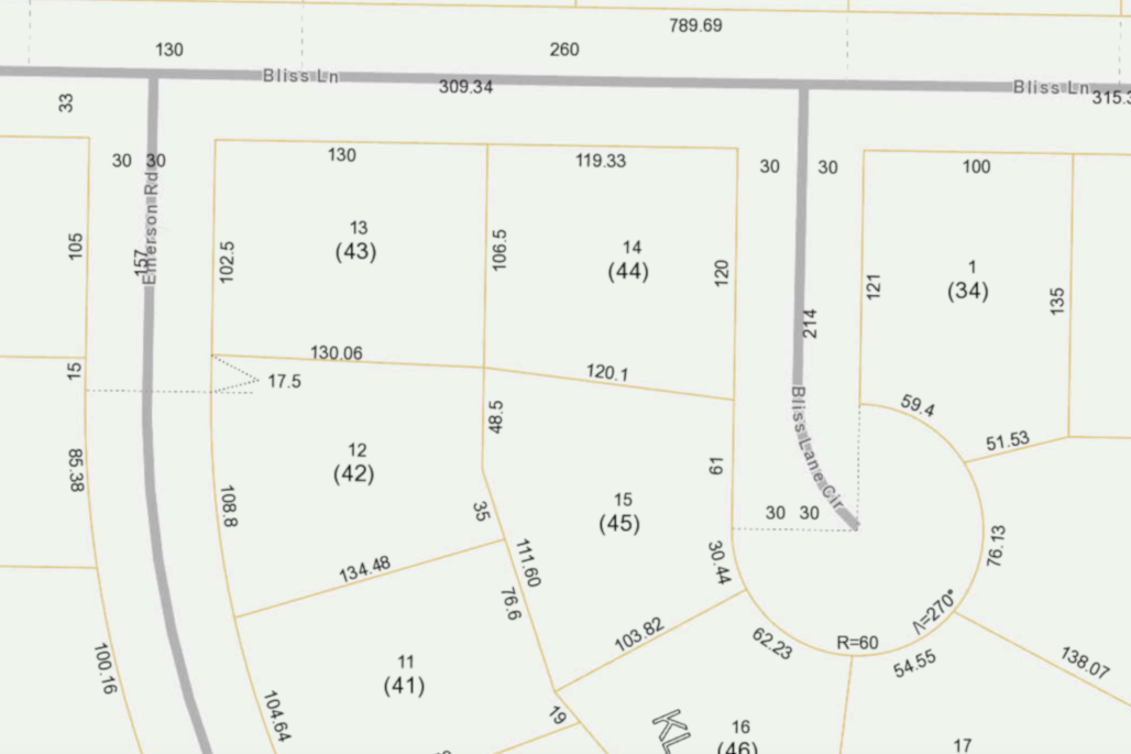
Another easier-to-follow document that will outline your property lines is the plat, or surveyor’s map. Your plat may be attached to your deed. If not, contact your local town or city ordinance for directions on how to access a copy.

The reason a plat is a much more accurate document than a deed is that it doesn’t just contain a description of your property lines, it also contains accurate diagrams. These diagrams may also reference fixed landmarks and accurate triangulation data to help you.
Use the plat like your deed; walk the boundary of your property using the information on the document. If boundaries are not easy to see, consider marking them as needed with stakes or paint, so you can determine the best position for your fence, addition, or other project.
Step 3: Check Your Boundaries for Physical Markers
Depending on where you live and the extent of development in your area, you may be able to get
clues to your property lines from markers such as iron pins, concrete markers, existing fences,
street lights, hedges, etc.
Walk the edge of where you believe your property to be, and look for anything that may mark a
corner or a boundary.
TIP: be aware that markers such as iron pins may have been moved, for example, during tree
removal or excavation. Keep in mind that it’s common to install a fence or a hedge a few feet
into your own property rather than placing it right on the border.
This is often because markers may move, and it can be safer – as well as respectful to your
neighbor – to make sure that what you erect is fully on your side of the boundary.
Step 4: Conduct a Basic Survey
Whether you choose to use a deed, plat, or basic markers, always take the time to walk the perimeter of your property. Use a compass and measuring tape to follow the directions you find on your documents.
If you notice that something is different – that a pin or block is not in the same location as was noted on the survey, make a note of its current position. Likewise, if something is missing, such as a boulder or tree that may have been noted on the boundary, make note of the fact that it is now gone.

Begin your survey from a fixed, known point that appears in your deed or plat. Follow the angles
and measurements listed, and keep an eye out for the noted markers.
If the markers are difficult to find or have been removed, consider placing your own for future
reference. If you find that your survey differs from the one on the deed or plat, make a drawing
and note the changes.
Remember, only a properly licensed surveyor can adjust incorrectly positioned property lines.
This can cost from a few hundred dollars to a thousand dollars or more. However, if you feel
your property lines are not correct, updating your survey before you begin a project could save
you legal fees and problems down the road.
TIP: If you’re planning to put up a fence, involve your neighbors in the process. It may not
always be practical, but there’s less chance of a problem arising if everyone affected is
consulted.
You may even be able to split some of the costs if the fence will be going up on the boundary line. Learn more about the cost of buiding fence before starting. If you feel there may be an error with your boundary lines, consult your neighbor’s deeds and plats for confirmation of mutual property lines.
How to Find Property Lines – Conclusion
Property lines are crucial for the correct placement of many types of fences and landscaping. Make sure you know where your boundaries are before you take on a major project. When you’re ready to begin, work out the amount of fencing you need with our fence calculator or vinyl fence calculator.