Acreage Calculator
Result
Total Acreage:
Acres:
Hectares:
Square Feet:
Square Meters:
Square Miles:
Square Kilometers:
Perimeter in Feet:
Perimeter in Meters:
How to Find the Grade of an Elevation
The grade of an elevation can be found by measuring the horizontal length of an elevation, also known as the run, and the vertical height of the elevation, or the rise.
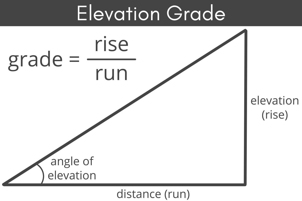
Elevation Grade Formula
Grade is expressed as rise/run, so if the rise is 25 and the run is 80, then the grade is 25/80. This can be reduced to 5/16; use our fraction simplifier to help reduce larger fractions if needed.
Run
Because many grades are shown as a percentage, such as the common 5% grade required for a patio
to drain, you will often find that you need to convert your fraction to a percentage. To find
the percent of incline of a grade, solve the rise/run fraction as a decimal, then convert to a
percentage.
For example, if the grade is 5/16, solve as a decimal by dividing 5 by 16, which gives you
0.3125.
To find the percentage multiply this decimal by 100%, like this: 0.3125 × 100% = 31.25%. For
comparison, something held at a 45-degree angle has a grade percentage of 100%.
The angle of incline can also be expressed in other units of angle measurement, such as radians
or grads. While this is less commonly needed by homeowners, laypersons, or landscapers, it may
be useful for some applications. You can use our angle converter to convert your slope from
degrees to one of these measurements.
How to Measure an Elevation
Whether you are calculating the rise of a slope in your backyard or the slope of your driveway, the measurements are typically done in a similar manner.
Step One: Measure the Run
First, you’ll need to mark the beginning and ending points of the rise.
This can be done using stakes or simply placing a marker on the ground. Measuring the distance
between your two markers to get your run.
Step Two: Measure the Rise
To measure your rise, you can use a device such as an altimeter to get your exact elevation at
each marker. Then simply subtract the elevation at the start of your run from the elevation at
the end of your run to get your rise.
In addition to an altimeter, you can also use surveying levels to help you measure the rise.
Dumpy levels, transit levels, and laser levels can all be used to help give you an accurate
measuring point at the bottom of your rise. Set up your level using a tripod at the endpoint of
the run, so that it is level with the top or endpoint, then measure from the ground to the level
to get the rise.
However, if you do not have access to an altimeter or surveying levels, you can measure the rise
manually.
Place a wooden stake at the end of the highest point in your elevation and tie a string to the
top. Walk the string out to the lowest point and hold it level – this can be checked with a
manual level or your phone’s level app held gently to the top of the string.
If possible, tie off the string to keep it level, or have an assistant hold it at level while
you measure the distance from the ground up to the string. This will give you the rise.
When measuring rise using any type of level – surveying or string – the measurement from the
ground to the level is your total rise. For example, if the measurement from the ground to the
level is 20 inches, then your rise is 20 inches.
Step Three: Calculate the Grade
Finally, divide the rise by the run to calculate the grade of the elevation. Then, simplify the fraction if necessary.